Categories
Geography

100+ MCQs on Mountains of India: Ultimate Quiz for Competitive Exams

Introduction

Mountains of India are a treasure trove of natural beauty and geographical significance, playing a vital role in the country’s climate, culture, and history. From the majestic Himalayas to the ancient Aravallis, these ranges are frequently covered in competitive exams like UPSC, SSC, Railways, and state PSCs. This comprehensive collection of 100+ MCQs on Mountains of India is designed to help students, aspirants, and general knowledge enthusiasts master key facts about India’s mountain ranges, peaks, and passes. Each question is followed by a concise one-liner explanation to reinforce learning and aid in exam preparation. Optimized with the keyword MCQs on Mountains of India, this article ensures you have the best resource to boost your GK and excel in competitive exams.

100 MCQs on Mountains of India with Answers and Explanations

  1. Which is the highest mountain peak in India?
    A) Mount Everest
    B) Kanchenjunga
    C) Nanda Devi
    D) K2
    Answer: B) Kanchenjunga
    Explanation: Kanchenjunga (8,586 m) is India’s highest peak, located in Sikkim.
  2. Which mountain range is the youngest in India?
    A) Aravalli
    B) Himalayas
    C) Western Ghats
    D) Satpura
    Answer: B) Himalayas
    Explanation: The Himalayas, formed 40-50 million years ago, are the youngest fold mountains in India.
  3. What is the highest peak in the Aravalli Range?
    A) Guru Shikhar
    B) Ser
    C) Achalgarh
    D) Taragarh
    Answer: A) Guru Shikhar
    Explanation: Guru Shikhar (1,722 m) is the highest peak in the Aravalli Range, located in Rajasthan.
  4. Which mountain range is known as the ‘Roof of South India’?
    A) Nilgiri Hills
    B) Anaimalai Hills
    C) Western Ghats
    D) Eastern Ghats
    Answer: C) Western Ghats
    Explanation: The Western Ghats, with peaks like Anamudi, are called the Roof of South India due to their elevation.
  5. Which is the highest peak in South India?
    A) Doddabetta
    B) Anamudi
    C) Velliangiri
    D) Chembra
    Answer: B) Anamudi
    Explanation: Anamudi (2,695 m) in Kerala is the highest peak in South India and the Western Ghats.
  6. Which mountain range separates the Kashmir Valley from the outer Himalayas?
    A) Pir Panjal
    B) Zanskar
    C) Shivalik
    D) Karakoram
    Answer: A) Pir Panjal
    Explanation: The Pir Panjal Range lies south of the Kashmir Valley, separating it from the outer Himalayas.
  7. Which pass connects Srinagar to Leh in the Himalayas?
    A) Banihal Pass
    B) Zoji La Pass
    C) Chang La Pass
    D) Diphu Pass
    Answer: B) Zoji La Pass
    Explanation: Zoji La Pass on NH-1 connects Srinagar to Leh in the Himalayan region.
  8. Which is the oldest mountain range in India?
    A) Himalayas
    B) Aravalli
    C) Vindhya
    D) Satpura
    Answer: B) Aravalli
    Explanation: The Aravalli Range is India’s oldest mountain range, formed over 1.5 billion years ago.
  9. Which mountain range is a UNESCO World Heritage Site?
    A) Eastern Ghats
    B) Western Ghats
    C) Aravalli Range
    D) Satpura Range
    Answer: B) Western Ghats
    Explanation: The Western Ghats are a UNESCO World Heritage Site due to their rich biodiversity.
  10. What is the meaning of the word ‘Himalaya’ in Sanskrit?
    A) Land of Peaks
    B) Abode of Snow
    C) Land of Rivers
    D) Mountain of Gods
    Answer: B) Abode of Snow
    Explanation: Himalaya translates to “Abode of Snow” in Sanskrit, reflecting its snow-covered peaks.
  11. Which is the highest peak in the Eastern Ghats?
    A) Arma Konda
    B) Mahendragiri
    C) Deomali
    D) Jindhagada
    Answer: A) Arma Konda
    Explanation: Arma Konda (1,680 m) in Andhra Pradesh is the highest peak in the Eastern Ghats.
  12. Which mountain range lies between the Narmada and Tapi rivers?
    A) Satpura Range
    B) Vindhya Range
    C) Aravalli Range
    D) Western Ghats
    Answer: A) Satpura Range
    Explanation: The Satpura Range is located between the Narmada and Tapi rivers in central India.
  13. Which is the highest peak in the Satpura Range?
    A) Dhupgarh
    B) Amarkantak
    C) Sad-Bhawna Shikhar
    D) Mahadeo
    Answer: A) Dhupgarh
    Explanation: Dhupgarh (1,350 m) in Madhya Pradesh is the highest peak in the Satpura Range.
  14. Which pass is located in the Pir Panjal Range?
    A) Banihal Pass
    B) Rohtang Pass
    C) Shipki La
    D) Karakoram Pass
    Answer: A) Banihal Pass
    Explanation: Banihal Pass connects the Kashmir Valley to the outer Himalayas via the Pir Panjal Range.
  15. Which mountain peak is known as ‘Sagar Matha’?
    A) Kanchenjunga
    B) Mount Everest
    C) Nanda Devi
    D) K2
    Answer: B) Mount Everest
    Explanation: Mount Everest is called ‘Sagar Matha’ in Nepali, meaning “Peak of Heaven.”
  16. Which mountain range runs parallel to the Bay of Bengal?
    A) Western Ghats
    B) Eastern Ghats
    C) Aravalli Range
    D) Vindhya Range
    Answer: B) Eastern Ghats
    Explanation: The Eastern Ghats run parallel to the Bay of Bengal along India’s eastern coast.
  17. Which is the highest peak in the Nilgiri Hills?
    A) Anamudi
    B) Doddabetta
    C) Velliangiri
    D) Chembra
    Answer: B) Doddabetta
    Explanation: Doddabetta (2,637 m) in Tamil Nadu is the highest peak in the Nilgiri Hills.
  18. Which mountain range is known as ‘Sahyadri’?
    A) Western Ghats
    B) Eastern Ghats
    C) Aravalli Range
    D) Vindhya Range
    Answer: A) Western Ghats
    Explanation: The Western Ghats are called ‘Sahyadri’ in Maharashtra and Karnataka.
  19. Which pass is a Trans-Himalayan pass?
    A) Rohtang Pass
    B) Aghil Pass
    C) Banihal Pass
    D) Thaga La
    Answer: B) Aghil Pass
    Explanation: Aghil Pass is a Trans-Himalayan pass near the Shaksgam Valley, annexed by China.
  20. Which state is home to Nanda Devi peak?
    A) Sikkim
    B) Uttarakhand
    C) Himachal Pradesh
    D) Arunachal Pradesh
    Answer: B) Uttarakhand
    Explanation: Nanda Devi (7,816 m) is located in the Garhwal Himalayas in Uttarakhand.
  21. Which mountain range blocks rain-carrying winds to the Thar Desert?
    A) Himalayas
    B) Aravalli Range
    C) Western Ghats
    D) Satpura Range
    Answer: B) Aravalli Range
    Explanation: The Aravalli Range blocks monsoon winds, contributing to the Thar Desert’s aridity.
  22. Which is the highest peak in the Andaman and Nicobar Islands?
    A) Saddle Peak
    B) Mount Harriet
    C) Mount Thuillier
    D) Mount Diavolo
    Answer: A) Saddle Peak
    Explanation: Saddle Peak (732 m) in North Andaman is the highest peak in the Andaman and Nicobar Islands.
  23. Which mountain range is formed due to the collision of the Indian and Eurasian plates?
    A) Aravalli Range
    B) Himalayas
    C) Western Ghats
    D) Satpura Range
    Answer: B) Himalayas
    Explanation: The Himalayas were formed by the collision of the Indian and Eurasian tectonic plates.
  24. Which is the highest peak in the Vindhya Range?
    A) Sad-Bhawna Shikhar
    B) Amarkantak
    C) Dhupgarh
    D) Mahadeo
    Answer: A) Sad-Bhawna Shikhar
    Explanation: Sad-Bhawna Shikhar is the highest peak in the Vindhya Range.
  25. Which pass is located between Mumbai and Pune?
    A) Thalghat
    B) Banihal Pass
    C) Palghat
    D) Shenkota
    Answer: A) Thalghat
    Explanation: Thalghat Pass in the Western Ghats connects Mumbai and Pune.
  26. Which mountain range is known as ‘Manak Parbat’ in ancient times?
    A) Pir Panjal
    B) Shivalik Hills
    C) Zanskar Range
    D) Karakoram
    Answer: B) Shivalik Hills
    Explanation: Shivalik Hills, meaning ‘tresses of Lord Shiva,’ were called Manak Parbat in ancient times.
  27. Which is the highest peak in the Mahadev Range?
    A) Panchmarhi
    B) Dhupgarh
    C) Amarkantak
    D) Mahadeo
    Answer: A) Panchmarhi
    Explanation: Panchmarhi is the highest peak in the Mahadev Range in Madhya Pradesh.
  28. Which mountain range is located in the eastern part of the Indian Peninsula?
    A) Western Ghats
    B) Eastern Ghats
    C) Aravalli Range
    D) Vindhya Range
    Answer: B) Eastern Ghats
    Explanation: The Eastern Ghats run along the eastern coast of the Indian Peninsula.
  29. Which is the highest peak in the Karakoram Range in India?
    A) K2
    B) Kanchenjunga
    C) Saltoro Kangri
    D) Nanda Devi
    Answer: C) Saltoro Kangri
    Explanation: Saltoro Kangri (7,742 m) is the highest peak in the Karakoram Range in India.
  30. Which state is home to Mount Abu?
    A) Gujarat
    B) Rajasthan
    C) Haryana
    D) Delhi
    Answer: B) Rajasthan
    Explanation: Mount Abu, a popular hill station, is located in the Aravalli Range in Rajasthan.
  31. Which is the highest peak in the Garhwal Himalayas?
    A) Nanda Devi
    B) Kamet
    C) Trishul
    D) Gosain Than
    Answer: A) Nanda Devi
    Explanation: Nanda Devi (7,816 m) is the highest peak in the Garhwal Himalayas, Uttarakhand.
  32. Which mountain pass is located on the India-China border?
    A) Shipki La
    B) Rohtang Pass
    C) Banihal Pass
    D) Thalghat
    Answer: A) Shipki La
    Explanation: Shipki La (3,930 m) is a high mountain pass on the India-China border.
  33. Which mountain range is the source of the Brahmaputra River?
    A) Karakoram
    B) Himalayas
    C) Aravalli
    D) Western Ghats
    Answer: B) Himalayas
    Explanation: The Brahmaputra originates in the Himalayas near the Kailash Range in Tibet.
  34. Which peak is known as the ‘Everest of South India’?
    A) Doddabetta
    B) Anamudi
    C) Velliangiri
    D) Chembra
    Answer: B) Anamudi
    Explanation: Anamudi (2,695 m) is often called the ‘Everest of South India’ due to its height.
  35. Which mountain range is situated between Manipur and Nagaland?
    A) Barail Hills
    B) Purvanchal Range
    C) Shivalik Hills
    D) Aravalli Range
    Answer: A) Barail Hills
    Explanation: The Barail Hills separate Manipur and Nagaland in northeastern India.
  36. Which is the highest peak in the Western Ghats in Karnataka?
    A) Mullayanagiri
    B) Kudremukh
    C) Tadiandamol
    D) Pushpagiri
    Answer: A) Mullayanagiri
    Explanation: Mullayanagiri (1,925 m) is the highest peak in Karnataka’s Western Ghats.
  37. Which pass connects the Kashmir Valley to Jammu?
    A) Zoji La
    B) Banihal Pass
    C) Rohtang Pass
    D) Shipki La
    Answer: B) Banihal Pass
    Explanation: Banihal Pass connects the Kashmir Valley to Jammu in the Pir Panjal Range.
  38. Which mountain range is the oldest fold mountain in India?
    A) Aravalli Range
    B) Himalayas
    C) Satpura Range
    D) Vindhya Range
    Answer: A) Aravalli Range
    Explanation: The Aravalli Range is considered the oldest fold mountain range in India.
  39. Which is the highest peak in the Kumaon Himalayas?
    A) Nanda Devi
    B) Kamet
    C) Trishul
    D) Gosain Than
    Answer: B) Kamet
    Explanation: Kamet (7,756 m) is the highest peak in the Kumaon Himalayas, Uttarakhand.
  40. Which mountain range is located in the states of Tamil Nadu, Kerala, and Karnataka?
    A) Western Ghats
    B) Eastern Ghats
    C) Aravalli Range
    D) Satpura Range
    Answer: A) Western Ghats
    Explanation: The Western Ghats span Tamil Nadu, Kerala, and Karnataka, among other states.
  41. Which is the highest peak in the Palani Hills?
    A) Vandaravu
    B) Anamudi
    C) Doddabetta
    D) Kodaikanal
    Answer: A) Vandaravu
    Explanation: Vandaravu (2,553 m) is the highest peak in the Palani Hills, Tamil Nadu.
  42. Which mountain pass is located in the Western Ghats?
    A) Palghat Pass
    B) Banihal Pass
    C) Shipki La
    D) Karakoram Pass
    Answer: A) Palghat Pass
    Explanation: Palghat Pass is located in the Western Ghats in southwestern India.
  43. Which is the highest peak in the Naga Hills?
    A) Saramati
    B) Japfu
    C) Mount Tempu
    D) Dapha Bum
    Answer: A) Saramati
    Explanation: Saramati (3,826 m) is the highest peak in the Naga Hills, Nagaland.
  44. Which mountain range is home to the Siachen Glacier?
    A) Karakoram
    B) Himalayas
    C) Zanskar
    D) Pir Panjal
    Answer: A) Karakoram
    Explanation: The Siachen Glacier is located in the Karakoram Range, the world’s largest mountainous glacier.
  45. Which is the highest peak in the Anaimalai Hills?
    A) Anamudi
    B) Doddabetta
    C) Vandaravu
    D) Meesapulimala
    Answer: A) Anamudi
    Explanation: Anamudi (2,695 m) is the highest peak in the Anaimalai Hills, Kerala.
  46. Which mountain range is known as the ‘Outer Himalayas’?
    A) Shivalik Hills
    B) Greater Himalayas
    C) Lesser Himalayas
    D) Trans-Himalayas
    Answer: A) Shivalik Hills
    Explanation: The Shivalik Hills are the outermost range of the Himalayas, also called the Outer Himalayas.
  47. Which is the highest peak in the Mizo Hills?
    A) Phawngpui
    B) Reiek
    C) Hmuifang
    D) Lengteng
    Answer: A) Phawngpui
    Explanation: Phawngpui (2,157 m), also known as Blue Mountain, is the highest peak in Mizoram.
  48. Which pass connects Arunachal Pradesh with Tibet?
    A) Bomdila Pass
    B) Jelep La
    C) Karakoram Pass
    D) Rohtang Pass
    Answer: B) Jelep La
    Explanation: Jelep La connects Arunachal Pradesh with Tibet in the eastern Himalayas.
  49. Which mountain range is the source of the Indus River?
    A) Karakoram
    B) Himalayas
    C) Zanskar
    D) Pir Panjal
    Answer: B) Himalayas
    Explanation: The Indus River originates near Lake Mansarovar in the Himalayas, Tibet.
  50. Which is the highest peak in the Khasi Hills?
    A) Shillong Peak
    B) Nokrek
    C) Lum Sohpetbneng
    D) Tura Peak
    Answer: A) Shillong Peak
    Explanation: Shillong Peak (1,965 m) is the highest peak in the Khasi Hills, Meghalaya.
  51. Which mountain range is located in the state of Gujarat?
    A) Aravalli Range
    B) Western Ghats
    C) Eastern Ghats
    D) Satpura Range
    Answer: A) Aravalli Range
    Explanation: The Aravalli Range extends into Gujarat, covering parts of the state.
  52. Which is the highest peak in the Chota Nagpur Plateau?
    A) Parasnath
    B) Trikut
    C) Rajgir
    D) Brahmayoni
    Answer: A) Parasnath
    Explanation: Parasnath (1,350 m) in Jharkhand is the highest peak in the Chota Nagpur Plateau.
  53. Which mountain pass is located in Himachal Pradesh?
    A) Rohtang Pass
    B) Banihal Pass
    C) Thalghat
    D) Palghat Pass
    Answer: A) Rohtang Pass
    Explanation: Rohtang Pass connects Kullu Valley with Lahaul and Spiti in Himachal Pradesh.
  54. Which is the highest peak in the Purvanchal Range?
    A) Dapha Bum
    B) Saramati
    C) Mount Tempu
    D) Phawngpui
    Answer: A) Dapha Bum
    Explanation: Dapha Bum (4,571 m) in Arunachal Pradesh is the highest peak in the Purvanchal Range.
  55. Which mountain range is home to the Kanchenjunga peak?
    A) Karakoram
    B) Himalayas
    C) Zanskar
    D) Pir Panjal
    Answer: B) Himalayas
    Explanation: Kanchenjunga (8,586 m) is part of the Himalayas, shared by Sikkim and Nepal.
  56. Which is the highest peak in the Cardamom Hills?
    A) Anamudi
    B) Meesapulimala
    C) Agasthyamalai
    D) Doddabetta
    Answer: C) Agasthyamalai
    Explanation: Agasthyamalai (1,868 m) is the highest peak in the Cardamom Hills, Kerala.
  57. Which mountain range is known for its fold mountain structure?
    A) Aravalli Range
    B) Western Ghats
    C) Himalayas
    D) Eastern Ghats
    Answer: C) Himalayas
    Explanation: The Himalayas are fold mountains formed by tectonic plate collisions.
  58. Which is the highest peak in the Jaintia Hills?
    A) Shillong Peak
    B) Lum Umlyngkha
    C) Nokrek
    D) Tura Peak
    Answer: B) Lum Umlyngkha
    Explanation: Lum Umlyngkha (1,729 m) is the highest peak in the Jaintia Hills, Meghalaya.
  59. Which pass connects Sikkim with Tibet?
    A) Nathu La
    B) Jelep La
    C) Bomdila Pass
    D) Shipki La
    Answer: A) Nathu La
    Explanation: Nathu La is a major pass connecting Sikkim with Tibet in the Himalayas.
  60. Which mountain range is the source of the Ganga River?
    A) Karakoram
    B) Himalayas
    C) Zanskar
    D) Pir Panjal
    Answer: B) Himalayas
    Explanation: The Ganga originates from the Gangotri Glacier in the Himalayas, Uttarakhand.
  61. Which is the highest peak in the Rajmahal Hills?
    A) Parasnath
    B) Gorgaburu
    C) Trikut
    D) Brahmayoni
    Answer: B) Gorgaburu
    Explanation: Gorgaburu (677 m) is the highest peak in the Rajmahal Hills, Jharkhand.
  62. Which mountain range is located in the state of Odisha?
    A) Eastern Ghats
    B) Western Ghats
    C) Aravalli Range
    D) Satpura Range
    Answer: A) Eastern Ghats
    Explanation: The Eastern Ghats extend through Odisha, hosting peaks like Deomali.
  63. Which is the highest peak in the Manipur Hills?
    A) Mount Tempu
    B) Saramati
    C) Dapha Bum
    D) Phawngpui
    Answer: A) Mount Tempu
    Explanation: Mount Tempu (2,994 m), also known as Mount Iso, is the highest peak in Manipur.
  64. Which pass is located in the Zanskar Range?
    A) Pensi La
    B) Rohtang Pass
    C) Banihal Pass
    D) Thalghat
    Answer: A) Pensi La
    Explanation: Pensi La is a high-altitude pass in the Zanskar Range, Ladakh.
  65. Which mountain range is home to the Anamudi peak?
    A) Western Ghats
    B) Eastern Ghats
    C) Aravalli Range
    D) Satpura Range
    Answer: A) Western Ghats
    Explanation: Anamudi (2,695 m) is the highest peak in the Western Ghats, Kerala.
  66. Which is the highest peak in the Tripura Hills?
    A) Betlingchhip
    B) Jampui
    C) Sakhan
    D) Tlangsang
    Answer: A) Betlingchhip
    Explanation: Betlingchhip (930 m) is the highest peak in Tripura.
  67. Which mountain range is known for its residual mountain structure?
    A) Himalayas
    B) Aravalli Range
    C) Western Ghats
    D) Satpura Range
    Answer: B) Aravalli Range
    Explanation: The Aravalli Range is a residual mountain range, eroded over time.
  68. Which is the highest peak in the Dhauladhar Range?
    A) Hanuman Tibba
    B) Manimahesh Kailash
    C) Indrasan
    D) Deo Tibba
    Answer: A) Hanuman Tibba
    Explanation: Hanuman Tibba (5,982 m) is the highest peak in the Dhauladhar Range, Himachal Pradesh.
  69. Which pass connects Ladakh with Tibet?
    A) Khardung La
    B) Chang La
    C) Karakoram Pass
    D) Nathu La
    Answer: C) Karakoram Pass
    Explanation: Karakoram Pass connects Ladakh with Tibet in the Karakoram Range.
  70. Which mountain range is home to the Shillong Plateau?
    A) Khasi Hills
    B) Garo Hills
    C) Jaintia Hills
    D) All of the above
    Answer: D) All of the above
    Explanation: The Shillong Plateau encompasses the Khasi, Garo, and Jaintia Hills in Meghalaya.
  71. Which is the highest peak in the Garo Hills?
    A) Nokrek
    B) Tura Peak
    C) Shillong Peak
    D) Lum Umlyngkha
    Answer: A) Nokrek
    Explanation: Nokrek (1,412 m) is the highest peak in the Garo Hills, Meghalaya.
  72. Which mountain range is the source of the Yamuna River?
    A) Karakoram
    B) Himalayas
    C) Zanskar
    D) Pir Panjal
    Answer: B) Himalayas
    Explanation: The Yamuna River originates from the Yamunotri Glacier in the Himalayas, Uttarakhand.
  73. Which is the highest peak in the Western Ghats in Tamil Nadu?
    A) Anamudi
    B) Doddabetta
    C) Vandaravu
    D) Meesapulimala
    Answer: B) Doddabetta
    Explanation: Doddabetta (2,637 m) is the highest peak in the Western Ghats in Tamil Nadu.
  74. Which pass is located in the Dhauladhar Range?
    A) Indrahar Pass
    B) Rohtang Pass
    C) Banihal Pass
    D) Thalghat
    Answer: A) Indrahar Pass
    Explanation: Indrahar Pass is a high-altitude pass in the Dhauladhar Range, Himachal Pradesh.
  75. Which mountain range is home to the K2 peak?
    A) Himalayas
    B) Karakoram
    C) Zanskar
    D) Pir Panjal
    Answer: B) Karakoram
    Explanation: K2 (8,611 m) is located in the Karakoram Range on the China-Pakistan border.
  76. Which is the highest peak in the Shivsiwalik Range?
    A) Kamet
    B) Nanda Devi
    C) No specific peak
    D) Trishul
    Answer: C) No specific peak
    Explanation: The Shivalik Range is a low-altitude range with no prominent single highest peak.
  77. Which mountain pass connects Kullu with Lahaul?
    A) Rohtang Pass
    B) Baralacha La
    C) Kunzum Pass
    D) Shipki La
    Answer: A) Rohtang Pass
    Explanation: Rohtang Pass connects Kullu Valley with Lahaul in Himachal Pradesh.
  78. Which is the highest peak in the Western Ghats in Maharashtra?
    A) Kalsubai
    B) Mahabaleshwar
    C) Torna
    D) Salher
    Answer: A) Kalsubai
    Explanation: Kalsubai (1,646 m) is the highest peak in the Western Ghats in Maharashtra.
  79. Which mountain range is home to the Namik Glacier?
    A) Himalayas
    B) Karakoram
    C) Zanskar
    D) Pir Panjal
    Answer: A) Himalayas
    Explanation: Namik Glacier is located in the Himalayas, Pithoragarh, Uttarakhand.
  80. Which is the highest peak in the Vindhya Range in Madhya Pradesh?
    A) Sad-Bhawna Shikhar
    B) Amarkantak
    C) Dhupgarh
    D) Mahadeo
    Answer: A) Sad-Bhawna Shikhar
    Explanation: Sad-Bhawna Shikhar is the highest peak in the Vindhya Range in Madhya Pradesh.
  81. Which pass connects Himachal Pradesh with Tibet?
    A) Shipki La
    B) Nathu La
    C) Jelep La
    D) Rohtang Pass
    Answer: A) Shipki La
    Explanation: Shipki La connects Himachal Pradesh with Tibet on the India-China border.
  82. Which mountain range is home to the Anaimalai Hills?
    A) Western Ghats
    B) Eastern Ghats
    C) Aravalli Range
    D) Satpura Range
    Answer: A) Western Ghats
    Explanation: The Anaimalai Hills are part of the Western Ghats in Kerala and Tamil Nadu.
  83. Which is the highest peak in the Western Ghats in Kerala?
    A) Anamudi
    B) Meesapulimala
    C) Agasthyamalai
    D) Doddabetta
    Answer: A) Anamudi
    Explanation: Anamudi (2,695 m) is the highest peak in the Western Ghats in Kerala.
  84. Which mountain range is home to the Hispar Glacier?
    A) Karakoram
    B) Himalayas
    C) Zanskar
    D) Pir Panjal
    Answer: A) Karakoram
    Explanation: The Hispar Glacier is located in the Karakoram Range, feeding the Hunza River.
  85. Which is the highest peak in the Western Ghats in Tamil Nadu?
    A) Doddabetta
    B) Anamudi
    C) Vandaravu
    D) Meesapulimala
    Answer: A) Doddabetta
    Explanation: Doddabetta (2,637 m) is the highest peak in the Western Ghats in Tamil Nadu.
  86. Which mountain pass is located in the Eastern Ghats?
    A) Palghat Pass
    B) Ghataprabha Pass
    C) Banihal Pass
    D) Rohtang Pass
    Answer: A) Palghat Pass
    Explanation: Palghat Pass is a significant pass in the Eastern Ghats.
  87. Which is the highest peak in the Western Ghats in Karnataka?
    A) Mullayanagiri
    B) Kudremukh
    C) Tadiandamol
    D) Pushpagiri
    Answer: A) Mullayanagiri
    Explanation: Mullayanagiri (1,925 m) is the highest peak in the Western Ghats in Karnataka.
  88. Which mountain range is home to the Kalabaland Glacier?
    A) Himalayas
    B) Karakoram
    C) Zanskar
    D) Pir Panjal
    Answer: A) Himalayas
    Explanation: Kalabaland Glacier is located in the Himalayas, Pithoragarh, Uttarakhand.
  89. Which is the highest peak in the Western Ghats in Goa?
    A) Sonsogor
    B) Vagheri
    C) Chandranath
    D) Morlem
    Answer: A) Sonsogor
    Explanation: Sonsogor (1,166 m) is the highest peak in the Western Ghats in Goa.
  90. Which mountain pass is located in the Karakoram Range?
    A) Karakoram Pass
    B) Rohtang Pass
    B) Banihal Pass
    D) Thalghat
    Answer: A) Karakoram Pass
    Explanation: Karakoram Pass is a high-altitude pass in the Karakoram Range, Ladakh.
  91. Which is the highest peak in the Western Ghats in Andhra Pradesh?
    A) Arma Konda
    B) Deomali
    C) Mahendragiri
    D) Jindhagada
    Answer: A) Arma Konda
    Explanation: Arma Konda (1,680 m) is the highest peak in the Western Ghats in Andhra Pradesh.
  92. Which mountain range is home to the Gangotri Glacier?
    A) Karakoram
    B) Himalayas
    C) Zanskar
    D) Pir Panjal
    Answer: B) Himalayas
    Explanation: The Gangotri Glacier, source of the Ganga, is located in the Himalayas, Uttarakhand.
  93. Which is the highest peak in the Western Ghats in Telangana?
    A) Doli Gutta
    B) Ananthagiri
    C) Mahendragiri
    D) Deomali
    Answer: A) Doli Gutta
    Explanation: Doli Gutta (965 m) is the highest peak in the Western Ghats in Telangana.
  94. Which mountain pass connects Manali with Leh?
    A) Baralacha La
    B) Rohtang Pass
    C) Kunzum Pass
    D) Shipki La
    Answer: A) Baralacha La
    Explanation: Baralacha La connects Manali with Leh in the Himalayas, Himachal Pradesh.
  95. Which is the highest peak in the Western Ghats in Gujarat?
    A) Gorakhnath
    B) Girnar
    C) Saputara
    D) Wilson Hills
    Answer: A) Gorakhnath
    Explanation: Gorakhnath (1,117 m) is the highest peak in the Western Ghats in Gujarat.
  96. Which mountain range is home to the Yamunotri Glacier?
    A) Karakoram
    B) Himalayas
    C) Zanskar
    D) Pir Panjal
    Answer: B) Himalayas
    Explanation: The Yamunotri Glacier, source of the Yamuna, is located in the Himalayas, Uttarakhand.
  97. Which is the highest peak in the Western Ghats in Odisha?
    A) Deomali
    B) Mahendragiri
    C) Arma Konda
    D) Jindhagada
    Answer: A) Deomali
    Explanation: Deomali (1,672 m) is the highest peak in the Western Ghats in Odisha.
  98. Which mountain pass is located in the Shivalik Hills?
    A) Mohan Pass
    B) Rohtang Pass
    C) Banihal Pass
    D) Thalghat
    Answer: A) Mohan Pass
    Explanation: Mohan Pass is a low-altitude pass in the Shivalik Hills.
  99. Which is the highest peak in the Western Ghats in Madhya Pradesh?
    A) Dhupgarh
    B) Amarkantak
    C) Sad-Bhawna Shikhar
    D) Mahadeo
    Answer: A) Dhupgarh
    Explanation: Dhupgarh (1,350 m) is the highest peak in the Western Ghats in Madhya Pradesh.
  100. Which mountain range is home to the Nanda Devi National Park?
    A) Karakoram
    B) Himalayas
    C) Zanskar
    D) Pir Panjal
    Answer: B) Himalayas
    Explanation: Nanda Devi National Park is located in the Himalayas, surrounding the Nanda Devi peak.

Additional MCQs on Mountains of India

  1. Which is the highest peak in the Western Ghats in Tamil Nadu after Doddabetta?
    A) Mukurthi
    B) Vandaravu
    C) Perumal
    D) Meesapulimala
    Answer: A) Mukurthi
    Explanation: Mukurthi (2,554 m) is the second-highest peak in the Western Ghats in Tamil Nadu.
  2. Which mountain pass connects Arunachal Pradesh with Myanmar?
    A) Diphu Pass
    B) Jelep La
    C) Nathu La
    D) Bomdila Pass
    Answer: A) Diphu Pass
    Explanation: Diphu Pass connects Arunachal Pradesh with Myanmar in the eastern Himalayas.
  3. Which is the highest peak in the Assam Himalayas?
    A) Namcha Barwa
    B) Kanchenjunga
    C) Dapha Bum
    D) Saramati
    Answer: A) Namcha Barwa
    Explanation: Namcha Barwa (7,782 m) is the highest peak in the Assam Himalayas.
  4. Which mountain range is home to the Ralam Gad River?
    A) Himalayas
    B) Karakoram
    C) Zanskar
    D) Pir Panjal
    Answer: A) Himalayas
    Explanation: The Ralam Gad River originates from the Kalabaland Glacier in the Himalayas.
  5. Which is the highest peak in the Western Ghats in Andhra Pradesh after Arma Konda?
    A) Mahendragiri
    B) Deomali
    C) Jindhagada
    D) Sinkram
    Answer: B) Deomali
    Explanation: Deomali (1,672 m) is the second-highest peak in the Western Ghats in Andhra Pradesh.

Conclusion

This extensive collection of 100+ MCQs on Mountains of India is a valuable resource for students preparing for competitive exams like UPSC, SSC, Railways, and state PSCs. Covering major mountain ranges, peaks, and passes, these questions enhance your general knowledge and provide quick insights through concise explanations. By practicing these MCQs on Mountains of India, you can strengthen your understanding of India’s diverse geography and boost your exam performance. Keep revising and refer to trusted sources like NCERT for deeper learning. Conquer the mountains of knowledge and ace your exams!

Disclaimer

The following MCQs on Mountains of India are compiled from authentic sources for educational purposes to aid students in preparing for competitive examinations. While every effort has been made to ensure accuracy, users are advised to cross-verify information from standard textbooks like NCERT or other reliable sources. The author and publisher are not responsible for any errors or discrepancies that may arise during usage.

Also Read: Geography of India Objective Questions with Answers

Categories
Geography

Geography of India Objective Questions with Answers

Introduction

Geography is a vital subject for students preparing for competitive exams like SSC, CBSE, ICSE, and various graduate and postgraduate entrance tests. Understanding India’s diverse landscapes, rivers, climate, and resources is key to excelling in these exams. This article provides Geography of India objective questions with answers in a concise, one-liner format, designed to help students quickly grasp essential facts. With over 200 carefully curated questions, this resource is tailored to enhance your knowledge and exam readiness.

Geography of India Objective Questions with Answers

  1. What is the largest state in India by area?
    Answer: Rajasthan.
  2. Which river is known as the ‘Ganga of the South’?
    Answer: Godavari.
  3. What is the highest mountain peak in India?
    Answer: Kanchenjunga.
  4. Which is the longest river in India?
    Answer: Ganges.
  5. Which state is known for saffron cultivation?
    Answer: Jammu & Kashmir.
  6. Where is the Gulf of Kutch located?
    Answer: Gujarat.
  7. Which state benefits from the Sardar Sarovar Project?
    Answer: Gujarat, Rajasthan, Madhya Pradesh, Maharashtra.
  8. Why are oil refineries in India often near seaports?
    Answer: To facilitate crude oil imports.
  9. Which city is the southernmost point of India?
    Answer: Indira Point, Great Nicobar.
  10. What is the standard meridian of India?
    Answer: 82.5° E.
  11. Which state shares the longest border with Bangladesh?
    Answer: West Bengal.
  12. What is the largest desert in India?
    Answer: Thar Desert.
  13. Which mountain range runs parallel to India’s western coast?
    Answer: Western Ghats.
  14. What is the main soil type in the Deccan Plateau?
    Answer: Black soil.
  15. Which river forms the Sundarbans Delta?
    Answer: Ganges.
  16. What is the largest lagoon in India?
    Answer: Chilika Lake.
  17. Which state is known as the ‘Spice Garden of India’?
    Answer: Kerala.
  18. What is the longest coastline state in India?
    Answer: Gujarat.
  19. Which pass connects India with Tibet?
    Answer: Shipki La.
  20. What is the main source of irrigation in Punjab?
    Answer: Canals.
  21. Which river is called ‘Vridha Ganga’?
    Answer: Godavari.
  22. What is the largest wildlife sanctuary in India?
    Answer: Ranthambore National Park.
  23. Which state has the highest forest cover?
    Answer: Madhya Pradesh.
  24. What is the main crop of the Gangetic Plains?
    Answer: Rice.
  25. Which state is the largest producer of tea?
    Answer: Assam.
  26. What is the name of India’s highest waterfall?
    Answer: Jog Falls.
  27. Which river originates from the Gangotri Glacier?
    Answer: Ganges.
  28. What is the main type of vegetation in the Thar Desert?
    Answer: Xerophytic.
  29. Which state is known for the Kutch Salt Marshes?
    Answer: Gujarat.
  30. What is the largest delta in India?
    Answer: Sundarbans Delta.
  31. Which state has the most national parks?
    Answer: Madhya Pradesh.
  32. What is the main river of Tamil Nadu?
    Answer: Cauvery.
  33. Which state is the largest producer of coffee?
    Answer: Karnataka.
  34. What is the name of the pass connecting Sikkim with Tibet?
    Answer: Jelep La.
  35. Which river is known as the ‘Lifeline of Goa’?
    Answer: Mandovi.
  36. What is the largest saltwater lake in India?
    Answer: Chilika Lake.
  37. Which state is the largest producer of sugarcane?
    Answer: Uttar Pradesh.
  38. What is the main mineral found in Jharkhand?
    Answer: Coal.
  39. Which river forms the Dhuadhar Falls?
    Answer: Narmada.
  40. What is the largest plateau in India?
    Answer: Deccan Plateau.
  41. Which state is known for the Aravalli Range?
    Answer: Rajasthan.
  42. What is the main type of climate in India?
    Answer: Tropical Monsoon.
  43. Which river is called the ‘Sorrow of Bihar’?
    Answer: Kosi.
  44. What is the largest coral reef in India?
    Answer: Andaman and Nicobar Islands.
  45. Which state is the largest producer of rice?
    Answer: West Bengal.
  46. What is the name of India’s largest glacier?
    Answer: Siachen Glacier.
  47. Which river is known as the ‘Tsangpo’ in Tibet?
    Answer: Brahmaputra.
  48. What is the main soil type in the Indo-Gangetic Plains?
    Answer: Alluvial soil.
  49. Which state has the longest international border?
    Answer: West Bengal.
  50. What is the largest biosphere reserve in India?
    Answer: Nilgiri Biosphere Reserve.
  51. Which river forms the Bhagirathi-Hooghly system?
    Answer: Ganges.
  52. What is the main crop of Punjab?
    Answer: Wheat.
  53. Which state is known for the Sundarbans?
    Answer: West Bengal.
  54. What is the largest port in India?
    Answer: Mumbai Port.
  55. Which river is known as the ‘Dakshin Ganga’?
    Answer: Godavari.
  56. What is the main source of power in Himachal Pradesh?
    Answer: Hydropower.
  57. Which state is the largest producer of bauxite?
    Answer: Odisha.
  58. What is the name of the highest dam in India?
    Answer: Tehri Dam.
  59. Which river is associated with the Nagarjuna Sagar Dam?
    Answer: Krishna.
  60. What is the main type of forest in the Western Ghats?
    Answer: Tropical Evergreen.
  61. Which state is known for the Gir Forest?
    Answer: Gujarat.
  62. What is the largest island in India?
    Answer: Andaman Island.
  63. Which river is known as the ‘Sorrow of Odisha’?
    Answer: Mahanadi.
  64. What is the main mineral of Goa?
    Answer: Iron ore.
  65. Which state is the largest producer of cotton?
    Answer: Gujarat.
  66. What is the name of India’s largest lake?
    Answer: Wular Lake.
  67. Which river forms the Jog Falls?
    Answer: Sharavati.
  68. What is the main soil type in Rajasthan?
    Answer: Sandy soil.
  69. Which state is known for the Kaziranga National Park?
    Answer: Assam.
  70. What is the largest mangrove forest in India?
    Answer: Sundarbans.
  71. Which river is associated with the Hirakud Dam?
    Answer: Mahanadi.
  72. What is the main crop of Andhra Pradesh?
    Answer: Rice.
  73. Which state is the largest producer of manganese?
    Answer: Madhya Pradesh.
  74. What is the name of the pass connecting Ladakh with Tibet?
    Answer: Khardung La.
  75. Which river is known as the ‘Lifeline of Kerala’?
    Answer: Periyar.
  76. What is the largest tiger reserve in India?
    Answer: Nagarjunasagar-Srisailam.
  77. Which state is known for the Bhimbetka Rock Shelters?
    Answer: Madhya Pradesh.
  78. What is the main type of vegetation in the Himalayas?
    Answer: Alpine.
  79. Which river forms the Marble Rocks at Bhedaghat?
    Answer: Narmada.
  80. What is the largest wetland in India?
    Answer: Sundarbans.
  81. Which state is the largest producer of jute?
    Answer: West Bengal.
  82. What is the name of India’s largest river island?
    Answer: Majuli.
  83. Which river is associated with the Tungabhadra Dam?
    Answer: Tungabhadra.
  84. What is the main mineral of Karnataka?
    Answer: Gold.
  85. Which state is known for the Valley of Flowers?
    Answer: Uttarakhand.
  86. What is the largest national park in India?
    Answer: Hemis National Park.
  87. Which river is known as the ‘Lifeline of Sikkim’?
    Answer: Teesta.
  88. What is the main soil type in Kerala?
    Answer: Laterite soil.
  89. Which state is the largest producer of tobacco?
    Answer: Andhra Pradesh.
  90. What is the name of the pass connecting Arunachal Pradesh with Myanmar?
    Answer: Pangsau Pass.
  91. Which river forms the Meenachil River system?
    Answer: Meenachil.
  92. What is the main crop of Haryana?
    Answer: Wheat.
  93. Which state is known for the Dachigam National Park?
    Answer: Jammu & Kashmir.
  94. What is the largest estuary in India?
    Answer: Hooghly Estuary.
  95. Which river is associated with the Bhakra Nangal Dam?
    Answer: Sutlej.
  96. What is the main mineral of Andhra Pradesh?
    Answer: Coal.
  97. Which state is the largest producer of silk?
    Answer: Karnataka.
  98. What is the name of India’s largest cave system?
    Answer: Meghalaya Caves.
  99. Which river is known as the ‘Lifeline of Madhya Pradesh’?
    Answer: Narmada.
  100. What is the largest bird sanctuary in India?
    Answer: Vedanthangal Bird Sanctuary.
  101. Which state is known for the Periyar National Park?
    Answer: Kerala.
  102. What is the main type of vegetation in the Andaman Islands?
    Answer: Tropical Rainforest.
  103. Which river forms the Stanley Falls?
    Answer: Krishna.
  104. What is the largest volcanic crater lake in India?
    Answer: Lonar Lake.
  105. Which state is the largest producer of mica?
    Answer: Andhra Pradesh.
  106. What is the name of the pass connecting Jammu with Srinagar?
    Answer: Banihal Pass.
  107. Which river is known as the ‘Lifeline of Odisha’?
    Answer: Mahanadi.
  108. What is the main crop of Tamil Nadu?
    Answer: Rice.
  109. Which state is known for the Jim Corbett National Park?
    Answer: Uttarakhand.
  110. What is the largest freshwater lake in India?
    Answer: Wular Lake.
  111. Which river is associated with the Gandhi Sagar Dam?
    Answer: Chambal.
  112. What is the main mineral of Rajasthan?
    Answer: Marble.
  113. Which state is the largest producer of pulses?
    Answer: Madhya Pradesh.
  114. What is the name of the pass connecting Himachal Pradesh with Tibet?
    Answer: Baralacha La.
  115. Which river is known as the ‘Lifeline of Chhattisgarh’?
    Answer: Mahanadi.
  116. What is the largest elephant reserve in India?
    Answer: Nilgiri Elephant Reserve.
  117. Which state is known for the Rann of Kutch?
    Answer: Gujarat.
  118. What is the main type of vegetation in the Eastern Ghats?
    Answer: Dry Deciduous.
  119. Which river forms the Kunchikal Falls?
    Answer: Varahi.
  120. What is the largest Ramsar site in India?
    Answer: Sundarbans.
  121. Which state is the largest producer of groundnut?
    Answer: Gujarat.
  122. What is the name of India’s largest wind farm?
    Answer: Jaisalmer Wind Park.
  123. Which river is associated with the Almatti Dam?
    Answer: Krishna.
  124. What is the main mineral of Tamil Nadu?
    Answer: Lignite.
  125. Which state is known for the Silent Valley National Park?
    Answer: Kerala.
  126. What is the largest man-made lake in India?
    Answer: Govind Ballabh Pant Sagar.
  127. Which river is known as the ‘Lifeline of Andhra Pradesh’?
    Answer: Krishna.
  128. What is the main crop of Karnataka?
    Answer: Rice.
  129. Which state is known for the Bandipur National Park?
    Answer: Karnataka.
  130. What is the largest coal mine in India?
    Answer: Gevra Coal Mine.
  131. Which river forms the Chitrakote Falls?
    Answer: Indravati.
  132. What is the main soil type in Tamil Nadu?
    Answer: Red soil.
  133. Which state is the largest producer of limestone?
    Answer: Rajasthan.
  134. What is the name of the pass connecting Uttarakhand with Tibet?
    Answer: Mana Pass.
  135. Which river is known as the ‘Lifeline of Tamil Nadu’?
    Answer: Cauvery.
  136. What is the largest marine national park in India?
    Answer: Gulf of Kutch Marine National Park.
  137. Which state is known for the Nanda Devi National Park?
    Answer: Uttarakhand.
  138. What is the main type of vegetation in Rajasthan?
    Answer: Thorny Scrub.
  139. Which river forms the Athirappilly Falls?
    Answer: Chalakudy.
  140. What is the largest oil refinery in India?
    Answer: Jamnagar Refinery.
  141. Which state is the largest producer of pepper?
    Answer: Kerala.
  142. What is the name of India’s largest solar park?
    Answer: Bhadla Solar Park.
  143. Which river is associated with the Sardar Sarovar Dam?
    Answer: Narmada.
  144. What is the main mineral of Kerala?
    Answer: Monazite.
  145. Which state is known for the Kanha National Park?
    Answer: Madhya Pradesh.
  146. What is the largest hydroelectric project in India?
    Answer: Koyna Hydroelectric Project.
  147. Which river is known as the ‘Lifeline of Gujarat’?
    Answer: Narmada.
  148. What is the main crop of Odisha?
    Answer: Rice.
  149. Which state is known for the Simlipal National Park?
    Answer: Odisha.
  150. What is the largest uranium mine in India?
    Answer: Tummalapalle Uranium Mine.
  151. Which river forms the Dudhsagar Falls?
    Answer: Mandovi.
  152. What is the main soil type in Gujarat?
    Answer: Black soil.
  153. Which state is the largest producer of gypsum?
    Answer: Rajasthan.
  154. What is the name of the pass connecting Sikkim with Bhutan?
    Answer: Nathu La.
  155. Which river is known as the ‘Lifeline of Karnataka’?
    Answer: Krishna.
  156. What is the largest crocodile sanctuary in India?
    Answer: Chambal Sanctuary.
  157. Which state is known for the Keoladeo National Park?
    Answer: Rajasthan.
  158. What is the main type of vegetation in Kerala?
    Answer: Tropical Wet Evergreen.
  159. Which river forms the Shivanasamudra Falls?
    Answer: Cauvery.
  160. What is the largest gas field in India?
    Answer: Krishna-Godavari Basin.
  161. Which state is the largest producer of cardamom?
    Answer: Kerala.
  162. What is the name of India’s largest nuclear power plant?
    Answer: Kudankulam Nuclear Power Plant.
  163. Which river is associated with the Mettur Dam?
    Answer: Cauvery.
  164. What is the main mineral of Odisha?
    Answer: Iron ore.
  165. Which state is known for the Sariska Tiger Reserve?
    Answer: Rajasthan.
  166. What is the largest thermal power plant in India?
    Answer: Vindhyachal Thermal Power Station.
  167. Which river is known as the ‘Lifeline of Rajasthan’?
    Answer: Luni.
  168. What is the main crop of West Bengal?
    Answer: Rice.
  169. Which state is known for the Namdapha National Park?
    Answer: Arunachal Pradesh.
  170. What is the largest zinc mine in India?
    Answer: Rampura Agucha Mine.
  171. Which river forms the Gandak Project?
    Answer: Gandak.
  172. What is the main soil type in Odisha?
    Answer: Red soil.
  173. Which state is the largest producer of dolomite?
    Answer: Chhattisgarh.
  174. What is the name of the pass connecting Arunachal Pradesh with Tibet?
    Answer: Bum La.
  175. Which river is known as the ‘Lifeline of West Bengal’?
    Answer: Hooghly.
  176. What is the largest butterfly park in India?
    Answer: Bannerghatta Butterfly Park.
  177. Which state is known for the Manas National Park?
    Answer: Assam.
  178. What is the main type of vegetation in Odisha?
    Answer: Moist Deciduous.
  179. Which river forms the Talakaveri?
    Answer: Cauvery.
  180. What is the largest copper mine in India?
    Answer: Malanjkhand Copper Mine.
  181. Which state is the largest producer of turmeric abitanti)?
    Answer: Tamil Nadu.
  182. What is the name of India’s largest irrigation canal?
    Answer: Indira Gandhi Canal.
  183. Which river is associated with the Farakka Barrage?
    Answer: Ganges.
  184. What is the main mineral of Gujarat?
    Answer: Lignite.
  185. Which state is known for the Pench National Park?
    Answer: Madhya Pradesh.
  186. What is the largest wind energy state in India?
    Answer: Tamil Nadu.
  187. Which river is known as the ‘Lifeline of Assam’?
    Answer: Brahmaputra.
  188. What is the main crop of Chhattisgarh?
    Answer: Rice.
  189. Which state is known for the Great Himalayan National Park?
    Answer: Himachal Pradesh.
  190. What is the largest lead mine in India?
    Answer: Zawar Mines.
  191. Which river forms the Kempty Falls?
    Answer: Yamuna.
  192. What is the main soil type in Chhattisgarh?
    Answer: Red soil.
  193. Which state is the largest producer of asbestos?
    Answer: Rajasthan.
  194. What is the name of the pass connecting Ladakh with China?
    Answer: Chang La.
  195. Which river is known as the ‘Lifeline of Jharkhand’?
    Answer: Damodar.
  196. What is the largest lion sanctuary in India?
    Answer: Gir National Park.
  197. Which state is known for the Dandeli Wildlife Sanctuary?
    Answer: Karnataka.
  198. What is the main type of vegetation in Chhattisgarh?
    Answer: Tropical Dry Deciduous.
  199. Which river forms the Hogenakkal Falls?
    Answer: Cauvery.
  200. What is the largest diamond mine in India?
    Answer: Panna Diamond Mine.

Geography of India Objective Questions with Answers: Conclusion

This comprehensive collection of Geography of India objective questions with answers is a valuable tool for SSC, CBSE, ICSE, graduate, and postgraduate students. By practicing these questions, you can strengthen your understanding of India’s geography and boost your confidence for competitive exams. Keep revising and stay prepared!

Geography of India Objective Questions with Answers: Disclaimer

The information provided in this article is for educational purposes only and is intended to assist students in preparing for competitive exams. While every effort has been made to ensure the accuracy of the content, we do not guarantee the completeness or correctness of the information. Users are advised to cross-check facts with reliable sources before relying on them for examinations. The author and publisher are not liable for any errors or omissions in the content.


Also Read: Monsoon Patterns in India Explained: A Complete Guide to Seasonal Rains

Categories
Geography

Monsoon Patterns in India Explained: A Complete Guide to Seasonal Rains

Understanding Monsoon Patterns in India: Causes, Impact & Climate Insights

Monsoon Patterns in India ExplainedOverview

India’s monsoon is one of the most vital weather phenomena, shaping the country’s agriculture, economy, and daily life. But how exactly do monsoon patterns in India work? Why do some regions receive heavy rainfall while others face droughts?

In this detailed guide, we’ll break down everything you need to know—from the science behind monsoons to their regional variations and socio-economic impact.

What Causes the Monsoon in India?

The Indian monsoon is primarily driven by seasonal wind shifts and temperature differences between land and sea. Here’s how it works:

1. The Role of the Southwest Monsoon (June-September)

  • Wind Movement: Moisture-laden winds from the Indian Ocean blow towards the Indian subcontinent.
  • Low-Pressure Zone: Intense summer heat over northern India creates a low-pressure area, pulling in winds from the high-pressure ocean.
  • Orographic Rainfall: The Western Ghats and Himalayas force these winds upward, causing heavy rainfall.

2. The Northeast Monsoon (October-December)

  • Wind Reversal: After September, winds reverse direction, moving from land to sea.
  • Limited Rainfall: Only Tamil Nadu, Andhra Pradesh, and parts of Karnataka receive significant rain during this phase.
Farmers in a rice field – Depicting agriculture dependency on monsoons, with laborers working under cloudy skies

Key Features of Indian Monsoon Patterns

1. Seasonal Variability

  • Onset & Withdrawal: The monsoon typically arrives in Kerala by early June and retreats by October.
  • Breaks & Active Phases: Periods of intense rainfall (active) and dry spells (breaks) are common.

2. Regional Variations

  • Western Ghats & Northeast India: Receive the heaviest rainfall (over 250 cm annually).
  • Rajasthan & Gujarat: Drier due to the rain-shadow effect of the Aravalli Range.
  • Tamil Nadu: Gets most of its rain from the northeast monsoon.

3. Impact of Climate Change

  • Erratic Rainfall: Rising temperatures are causing unpredictable monsoon behavior.
  • Extreme Weather Events: Increased frequency of floods and droughts.

Why Are Monsoons So Important for India?

1. Agriculture & Economy

  • Kharif Crops: Rice, sugarcane, and cotton depend on monsoon rains.
  • Water Supply: Reservoirs and groundwater recharge rely on seasonal rainfall.

2. Cultural & Social Impact

  • Festivals: Celebrations like Onam and Teej are tied to monsoon cycles.
  • Livelihoods: Farmers, fishermen, and traders adjust their work around monsoons.
A dramatic monsoon scene – Dark clouds over lush green fields in Kerala, with heavy rainfall and palm trees bending in the wind

FAQs About Monsoon Patterns in India

1. When does the monsoon start in India?

The southwest monsoon usually hits Kerala around June 1st and covers the entire country by mid-July.

2. Which part of India receives the highest rainfall?

Mawsynram (Meghalaya) holds the world record for the highest annual rainfall (about 11,871 mm).

3. How does El Niño affect the Indian monsoon?

El Niño often leads to weaker monsoons, causing droughts in India.

4. Why is the monsoon delayed sometimes?

Factors like ocean temperature changes, wind patterns, and global climate shifts can delay the monsoon.

5. Which states receive rain from the northeast monsoon?

Tamil Nadu, Andhra Pradesh, and Karnataka benefit from the northeast monsoon (Oct-Dec).

Monsoon Patterns in India: Final Thoughts

Understanding monsoon patterns in India is crucial for farmers, travelers, and policymakers alike. While the monsoon brings life-giving rains, its unpredictability due to climate change poses challenges.

If you found this guide helpful, check out our article on How Climate Change is Affecting India’s Weather or explore IMD’s monsoon updates for real-time data.

By grasping these monsoon dynamics, we can better appreciate India’s unique climate and prepare for its future changes.


Also Read: Major Rivers of India Explained: Origins, Roles, and Impact

Categories
Geography

Major Rivers of India Explained: Origins, Roles, and Impact

Exploring Major Rivers of India Explained

India’s rivers are the lifeblood of its culture, economy, and history, shaping civilizations for millennia. From the sacred Ganges to the mighty Brahmaputra, these waterways have nurtured agriculture, inspired spiritual traditions, and powered modern industries. Major rivers of India explained in street language means diving into their origins, their roles in shaping India’s past and present, and the challenges they face today. This guide explores seven key rivers—Ganges, Brahmaputra, Indus, Yamuna, Godavari, Krishna, and Narmada—unpacking their geographical, cultural, and economic significance. Whether you’re a student, traveler, or geography buff, join us to discover why these rivers are India’s heartbeat.

Overview of India’s Major Rivers

Rivers in India are more than just water bodies; they’re the backbone of its geography and culture. The major rivers of India explained include seven prominent ones: Ganges, Brahmaputra, Indus, Yamuna, Godavari, Krishna, and Narmada. These rivers support over 1.4 billion people, irrigating 40% of India’s farmland and generating 30% of its hydropower, according to the Ministry of Jal Shakti. They originate from diverse sources—Himalayan glaciers, Western Ghats, and central plateaus—shaping India’s varied landscapes. Their cultural significance is immense, with rivers like the Ganges revered as goddesses. Understanding these rivers offers insights into India’s history, economy, and environmental challenges.

Origins and Paths of Major Rivers

The major rivers of India explained begin with their unique origins and paths, each carving distinct geographical features. Here’s a closer look:

  • Ganges: Originates at Gangotri Glacier, Uttarakhand, flowing 2,525 km through North India to the Bay of Bengal.
  • Brahmaputra: Starts in Tibet’s Angsi Glacier, stretching 2,900 km through Northeast India, merging with the Ganges.
  • Indus: Begins in Tibet’s Kailash range, covering 3,180 km, primarily in Pakistan, with tributaries in India.
  • Yamuna: Rises at Yamunotri Glacier, Uttarakhand, flowing 1,376 km, joining the Ganges in Allahabad.
  • Godavari: Springs from Trimbakeshwar, Maharashtra, running 1,465 km across central India to the Bay of Bengal.
  • Krishna: Originates near Mahabaleshwar, Maharashtra, covering 1,400 km through southern states.
  • Narmada: Starts at Amarkantak, Madhya Pradesh, flowing 1,312 km westward to the Arabian Sea.

These rivers form two systems: Himalayan rivers (Ganges, Brahmaputra, Indus, Yamuna) with year-round flow from glaciers, and peninsular rivers (Godavari, Krishna, Narmada) reliant on monsoons. Their paths create fertile plains, deltas, and gorges, shaping India’s agriculture and settlements. For a deeper dive, explore Indian geography guide.

Historical and Cultural Significance

The cultural importance of Indian rivers is profound, with rivers like the Ganges central to India’s spiritual identity. The major rivers of India explained reveal their historical roles, starting with the Indus Valley Civilization (2600–1900 BCE). Cities like Harappa and Mohenjo-Daro thrived on the Indus, pioneering urban planning. The Ganges and Yamuna are sacred in Hinduism, mentioned in the Rigveda and linked to deities like Ganga and Yamuna. Festivals like Kumbh Mela, held every 12 years along the Ganges, draw millions, generating $15 billion in economic activity, per UNESCO. The Godavari and Krishna host Pushkaram festivals, celebrating their spiritual legacy. These rivers have shaped India’s art, literature, and traditions, making them cultural lifelines.

Rivers in Ancient Texts

Ancient texts like the Mahabharata and Puranas glorify rivers, portraying them as divine. The Ganges, for instance, is believed to cleanse sins, attracting pilgrims to sites like Varanasi. This spiritual connection underscores the major rivers of India explained as more than geographical features.

Economic Contributions of Major Rivers

The major rivers of India explained highlight their economic importance. They irrigate 60 million hectares of farmland, supporting crops like rice, wheat, and sugarcane, which contribute 20% to India’s GDP, per the Ministry of Agriculture. Major dams, such as Bhakra Nangal (Sutlej, a Ganges tributary) and Sardar Sarovar (Narmada), generate 40,000 MW of hydropower, powering millions of homes. Rivers also facilitate transportation, with the Ganges’ National Waterway-1 handling 10 million tonnes of cargo annually. Fisheries along the Godavari and Krishna sustain livelihoods for 5 million people. For more on India’s water resources, check Ministry of Jal Shakti.

Key Economic Roles

  • Irrigation: Ganges and Yamuna canals water 30% of India’s crops.
  • Hydropower: Narmada’s dams produce 1,450 MW.
  • Transport: Brahmaputra supports inland shipping in Assam.

Environmental Challenges Facing India’s Rivers

The challenges of India’s major rivers are critical to understanding the major rivers of India explained. Pollution is a major issue, with the Ganges receiving 3 billion liters of untreated sewage daily, per the Central Pollution Control Board. Industrial waste and agricultural runoff contaminate the Yamuna, rendering 70% of its water unfit for consumption. Over-extraction for irrigation depletes rivers like the Krishna, reducing downstream flow by 40%. Climate change exacerbates these issues, with Himalayan glacier melt threatening the Ganges and Brahmaputra’s flow by 20% by 2050, per IPCC reports. Deforestation along riverbanks, like the Narmada, increases soil erosion, silting riverbeds. These challenges demand urgent action to preserve India’s rivers.

RiverMajor IssueImpact
GangesSewage pollutionHealth risks for 400 million people
YamunaIndustrial waste80% water quality degradation
KrishnaOver-extractionReduced flow to deltas

Conservation Efforts and Future Outlook

Conservation is vital for the major rivers of India explained. The Namami Gange program, launched in 2014 with $3 billion, aims to clean the Ganges by 2030, building 100 sewage treatment plants. The National River Linking Project proposes connecting rivers like the Godavari and Krishna to address water scarcity, though it faces environmental concerns. Community initiatives, like the Narmada Bachao Andolan, advocate sustainable dam policies. Technology, such as real-time water quality monitoring, is being piloted on the Yamuna. For global insights, see National Geographic. The future depends on balancing development with conservation to ensure these rivers thrive.

Kumbh Mela festival on the Ganges (Cultural importance of Indian rivers).

Major Rivers in Indian Education and Tourism

The major rivers of India explained are central to education and tourism. In schools, rivers are a key geography topic, especially for competitive exams like UPSC, with 10–15% of questions on Indian geography. Students study river origins, tributaries, and economic roles. In tourism, the Ganges attracts 20 million visitors annually to Varanasi and Rishikesh, per the Ministry of Tourism. Godavari’s boat tours and Brahmaputra’s river cruises in Assam generate $500 million yearly. These rivers offer cultural immersion, from Kumbh Mela to Krishna’s Rajahmundry festivals, making them tourism gems.

Polluted Yamuna River in Delhi ( Challenges of India’s major rivers).

FAQs

What are the major rivers of India?

The major rivers of India explained include Ganges, Brahmaputra, Indus, Yamuna, Godavari, Krishna, and Narmada, vital for agriculture, culture, and energy.

Why are India’s rivers culturally significant?

Rivers like the Ganges and Yamuna are sacred in Hinduism, hosting festivals like Kumbh Mela and inspiring ancient texts, shaping India’s spiritual identity.

How do major rivers support India’s economy?

They irrigate 60 million hectares, generate 40,000 MW of hydropower, and support fisheries and transport, contributing 20% to GDP.

What challenges do India’s major rivers face?

Pollution, over-extraction, and climate change threaten rivers, with the Ganges and Yamuna facing severe water quality issues.

How are India’s rivers important for education?

The major rivers of India explained are key in school curricula and exams like UPSC, teaching geography and environmental awareness.

Conclusion

India’s rivers are the arteries of its civilization, from nurturing ancient cities to powering modern economies. The Ganges, Brahmaputra, Indus, and others shape agriculture, culture, and spirituality, while facing challenges like pollution and climate change. Conservation efforts like Namami Gange offer hope for their future. Whether you’re studying for exams or planning a river cruise, understanding these waterways deepens your appreciation of India. Share your favorite Indian river experience in the comments! The major rivers of India explained reveal a story of resilience and reverence.

Also Read: Indus River Historical Importance: A Journey Through Time


Categories
Geography

Indus River Historical Importance: A Journey Through Time

Unveiling the Indus River Historical Importance Across Millennia

Introduction

Imagine a river so vast and life-giving that it nurtured one of humanity’s earliest civilizations, shaping the course of history for millennia. The Indus River, often called the lifeline of the Indian subcontinent, has played an unparalleled role in human development. From its origins in the Himalayas to its delta in the Arabian Sea, the river’s historical importance is deeply woven into the fabric of ancient and modern societies.

This article delves into the Indus River historical importance, exploring how it served as the cradle of the Indus Valley Civilization, facilitated trade across continents, and became a cornerstone of cultural and religious traditions. Whether you’re a history enthusiast or simply curious about the roots of civilization, this journey will uncover why the Indus River remains a symbol of resilience and heritage. Let’s dive deeper into its timeless legacy.

Origins and Geography of the Indus River

The Indus River originates from the Tibetan Plateau, near Mount Kailash, and flows through the Himalayas before traversing the plains of Pakistan and emptying into the Arabian Sea. Spanning approximately 3,180 kilometers (1,980 miles), it is one of Asia’s longest rivers. Its path carves through diverse terrains, shaping fertile valleys and arid deserts along the way.

Geographically, the river’s significance lies in its ability to sustain ecosystems and human settlements. It feeds the Indus Basin, which supports agriculture, livestock, and millions of lives. The river’s annual flooding deposited nutrient-rich silt, creating fertile lands that were ideal for early farming communities.

The historical importance of the Indus River is evident in how it influenced migration patterns and settlement choices. Ancient populations gravitated toward its banks, drawn by the promise of water, food, and prosperity. This geographical advantage made the river not just a natural resource but a catalyst for societal evolution.

Map showing the Indus River’s course and major cities

Indus Valley Civilization and Historical Importance

The Indus Valley Civilization, also known as the Harappan Civilization, flourished around 2600 BCE along the banks of the Indus River. Cities like Mohenjo-Daro and Harappa stand as testaments to the ingenuity of this ancient society. These urban centers showcased advanced planning, with grid-like street layouts, drainage systems, and public baths.

Key features of Harappan cities include:

  • Sophisticated urban infrastructure: Streets aligned at right angles, multi-story buildings, and covered sewers.
  • Economic prosperity: Evidence of trade networks extending to Mesopotamia, Egypt, and beyond.
  • Cultural advancements: Artifacts such as seals, pottery, and jewelry reflect a rich artistic tradition.

The historical significance of the Indus River cannot be overstated here. It provided water for irrigation, transportation for goods, and a stable environment for innovation. Historians believe that the river’s predictable flooding cycles allowed the Harappans to develop surplus agriculture, freeing them to pursue other pursuits like art, trade, and governance.

However, the decline of the civilization around 1900 BCE remains a mystery. Some theories suggest climate change and shifts in the river’s course contributed to its downfall, underscoring the river’s dual role as both a nurturer and a force of nature.

Artifact from Mohenjo-Daro ( “Ancient seal highlighting Indus River cultural importance ”)

Indus River in Ancient Trade and Economy

The Indus River trade routes connected the subcontinent with distant regions, fostering economic growth and cultural exchange. Merchants transported goods such as cotton textiles, beads, and precious stones downriver, while importing copper, tin, and lapis lazuli from Central Asia and Mesopotamia.

Notable trade goods included:

  1. Cotton fabrics: Highly prized in ancient markets for their quality.
  2. Seals and amulets: Often inscribed with symbols, these items held ritualistic value.
  3. Metals and minerals: Essential for crafting tools and ornaments.

The river’s navigability made it a vital artery for commerce. Ships laden with goods sailed from ports like Lothal, reaching destinations as far as Mesopotamian cities. This exchange enriched not only economies but also ideas, technologies, and beliefs.

The Indus River historical importance in shaping trade networks highlights its role as a bridge between cultures. It laid the groundwork for globalization long before the term existed, proving that connectivity has always been key to human progress.

Cultural and Religious Significance of the Indus

Beyond economics, the Indus River cultural importance is profound. In Vedic texts, it is referred to as “Sindhu,” a sacred entity revered for its life-sustaining properties. The Rigveda, one of Hinduism’s oldest scriptures, frequently mentions the river, celebrating its purity and divinity.

Local traditions also honor the river through festivals and rituals. For instance, communities living along its banks perform pujas (prayers) to seek blessings for prosperity and protection. Even today, the river holds spiritual significance for millions.

The Indus River historical importance extends to its influence on mythology and folklore. Stories of gods descending to bathe in its waters or heroes embarking on quests along its length have been passed down through generations. These narratives underscore the river’s enduring place in the collective consciousness of South Asia.

Modern view of the Indus River (“Contemporary scene reflecting the Indus River historical importance ”)

Indus River in Medieval and Modern History

During the medieval period, the Indus River continued to shape regional dynamics. Under the Mughal Empire, it facilitated agricultural expansion and military campaigns. Akbar, the third Mughal emperor, recognized its strategic value and established garrisons along its banks.

In the colonial era, British engineers harnessed the river’s potential through irrigation projects, transforming barren lands into productive fields. However, these developments often disrupted local ecosystems and displaced indigenous communities.

Post-1947, the partition of India and Pakistan brought new challenges. The Indus Water Treaty of 1960, brokered by the World Bank, aimed to resolve disputes over water sharing. While effective in preventing conflict, tensions persist, highlighting the river’s ongoing relevance in geopolitics.

The historical importance of the Indus River in modern times reflects its dual identity as a unifier and divider, depending on political and environmental contexts.

Challenges and Preservation of the Indus River

Today, the Indus River faces numerous threats, including pollution, over-extraction, and climate change. Industrial waste, untreated sewage, and agricultural runoff have degraded water quality, endangering aquatic life and human health.

Water disputes between India and Pakistan further complicate conservation efforts. Both nations rely heavily on the river for irrigation and hydropower, making sustainable management a shared responsibility.

To preserve the Indus River historical importance, several measures can be implemented:

  • Restoration programs: Cleaning polluted stretches and reviving wetlands.
  • Community involvement: Educating locals about responsible water use.
  • Policy reforms: Strengthening international agreements to ensure equitable distribution.

By addressing these issues, we can safeguard the river’s legacy for future generations, ensuring it continues to inspire awe and admiration.

FAQs About the Indus River

  1. What is the historical importance of the Indus River?
    The Indus River historical importance lies in its role as the foundation of the Indus Valley Civilization, a hub for ancient trade, and a symbol of cultural and religious heritage.
  2. How did the Indus River shape the Harappan civilization?
    The river provided water, fertile soil, and a stable environment, enabling the Harappans to thrive and innovate.
  3. What role did the Indus River play in ancient trade?
    It served as a conduit for exchanging goods like cotton, metals, and gemstones with distant regions, fostering economic and cultural ties.
  4. Why is the Indus River significant in Indian culture?
    Revered in Vedic texts and local traditions, the river embodies spirituality and sustenance, shaping the cultural identity of South Asia.
  5. What are the main challenges facing the Indus River today?
    Pollution, water scarcity, and geopolitical disputes threaten its ecological balance and historical legacy.

Conclusion

The Indus River historical importance spans thousands of years, encompassing the rise of civilizations, the flourishing of trade, and the preservation of cultural traditions. As a source of life and inspiration, it reminds us of humanity’s deep connection to nature. Yet, its future depends on our commitment to conservation and cooperation.

Share your thoughts on the Indus River’s legacy in the comments below! Together, let’s celebrate and protect the enduring legacy of Indus River historical importance.

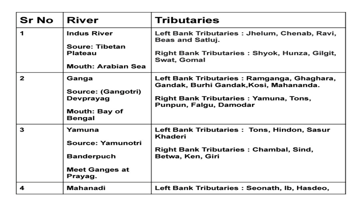
This video explains the Indus River system and its major tributaries — Jhelum, Chenab, Ravi, Beas, and Sutlej — which together form the Himalayan river system. It covers the exact locations where these rivers originate, the points where they drain, and highlights key places they flow through along their course.

Also Read: Why Athens is Called the City of the Violet Crown

Categories
Geography

Why Athens is Called the City of the Violet Crown

Discover the History Behind Athens City of the Violet Crown

Introduction

Athens, the capital of Greece, is famously known as the City of the Violet Crown due to its breathtaking purple-hued sunsets. This poetic name, first used by the Greek poet Pindar, reflects the city’s enchanting skies. Explore why Athens earned this unique title and its cultural significance.

Why Athens is Called the City of the Violet Crown

The City of the Violet Crown nickname comes from the stunning violet and purple shades that paint the Athenian sky at dusk. Key reasons include:

  • Pindar’s Poetry: The ancient Greek poet Pindar described Athens as a city with a “violet crown” in his works.
  • Unique Weather Conditions: Athens’ dry climate, low humidity, and clear skies enhance sunset colors.
  • Geographical Factors: The surrounding mountains and dust particles scatter light, creating vivid hues.

The Science Behind the Violet Skies

Athens’ mesmerizing sunsets result from natural phenomena:

  • Low Humidity: Dry air intensifies color saturation.
  • Dust Particles: These scatter sunlight, enhancing purple and pink tones.
  • Belt of Venus: A purple band visible at twilight adds to the spectacle.

Athens: A City of History and Beauty

Beyond its skies, Athens is renowned for:

  • Ancient Landmarks: The Acropolis, Parthenon, and Temple of Olympian Zeus.
  • Cultural Legacy: Birthplace of democracy, philosophy, and Western civilization.
  • Modern Vibrancy: A mix of historic charm and contemporary energy.

FAQs About Athens City of the Violet Crown

1. Who first called Athens the City of the Violet Crown?

The Greek poet Pindar first used the term in his writings.

2. What causes the violet hues in Athens’ sky?

Dry air, dust, and atmospheric conditions create vivid sunset colors.

3. Is the violet crown visible year-round?

Yes, but it’s most striking in summer due to clearer skies.

4. What other nicknames does Athens have?

Athens is also called the “Cradle of Western Civilization” and the “Birthplace of Democracy.”

Conclusion

Athens truly lives up to its name as the City of the Violet Crown, blending natural beauty with timeless history.


Also Read: 100 Geography GK Questions with Answers (One-Liners)

Categories
Geography

100 Geography GK Questions with Answers (One-Liners)

  1. Which is the largest continent in the world?
    Asia
  2. Which is the smallest continent in the world?
    Australia
  3. Which is the largest country in the world by area?
    Russia
  4. Which is the smallest country in the world by area?
    Vatican City
  5. What is the longest river in the world?
    Nile River
  6. Which river is known as the “Yellow River”?
    Huang He
  7. Which desert is the largest in the world?
    Sahara Desert
  8. What is the tallest mountain in the world?
    Mount Everest
  9. Which is the largest ocean on Earth?
    Pacific Ocean
  10. Which country is known as the “Land of the Rising Sun”?
    Japan
  11. What is the capital of Australia?
    Canberra
  12. Which country has the most number of islands?
    Sweden
  13. Which is the deepest ocean trench in the world?
    Mariana Trench
  14. Which line divides the Earth into Northern and Southern Hemispheres?
    Equator
  15. Which layer of Earth is made of solid rock?
    Crust
  16. Which country is known as the “Land of Thousand Lakes”?
    Finland
  17. What is the primary gas in Earth’s atmosphere?
    Nitrogen
  18. Which continent is known as the “Dark Continent”?
    Africa
  19. Which country is the largest producer of coffee?
    Brazil
  20. What is the smallest ocean in the world?
    Arctic Ocean
  21. What is the study of the Earth’s surface and its features called?
    Geography
  22. Which sea is the saltiest in the world?
    Dead Sea
  23. Which is the largest freshwater lake in the world?
    Lake Superior
  24. Which river is known as the “Ganga of the South”?
    Godavari
  25. What is the longest mountain range in the world?
    Andes
  26. Which is the largest island in the world?
    Greenland
  27. Which plateau is known as the “Roof of the World”?
    Tibetan Plateau
  28. Which country has the largest population in the world?
    China
  29. What is the capital of Canada?
    Ottawa
  30. Which river flows through Paris?
    Seine River
  31. Which is the coldest place on Earth?
    Antarctica
  32. What is the capital of Brazil?
    Brasília
  33. Which is the world’s largest archipelago?
    Indonesia
  34. Which mountain is called the “Savage Mountain”?
    K2
  35. Which country has the most volcanoes?
    Indonesia
  36. Which lake is the deepest in the world?
    Lake Baikal
  37. Which Indian state has the longest coastline?
    Gujarat
  38. Which desert is known as the “Cold Desert”?
    Gobi Desert
  39. What is the world’s largest coral reef system?
    Great Barrier Reef
  40. Which river is known as the “Father of Rivers”?
    Mississippi River
  41. Which city is known as the “City of Canals”?
    Venice
  42. Which country has the longest coastline in the world?
    Canada
  43. What is the hottest place on Earth?
    Death Valley
  44. Which city is known as the “City of Seven Hills”?
    Rome
  45. Which river is the longest in India?
    Ganga
  46. What is the capital of South Korea?
    Seoul
  47. Which country is known for the Great Wall?
    China
  48. Which river forms the Grand Canyon?
    Colorado River
  49. Which is the only floating national park in the world?
    Keibul Lamjao (India)
  50. Which is the largest hot desert in the world?
    Sahara
  51. Which island nation is located south of India?
    Sri Lanka
  52. What is the capital of France?
    Paris
  53. Which continent has the most number of countries?
    Africa
  54. Which ocean is the warmest?
    Indian Ocean
  55. Which river is called the “Lifeline of Egypt”?
    Nile
  56. Which is the largest saltwater lake in the world?
    Caspian Sea
  57. Which state in India is known as the “Land of Five Rivers”?
    Punjab
  58. What is the highest waterfall in the world?
    Angel Falls
  59. Which country is known as the “Land of Fire and Ice”?
    Iceland
  60. What is the capital of Japan?
    Tokyo
  61. Which river flows through London?
    Thames
  62. Which mountain range separates Europe and Asia?
    Ural Mountains
  63. What is the largest peninsula in the world?
    Arabian Peninsula
  64. What is the capital of Russia?
    Moscow
  65. Which sea lies between Europe and Africa?
    Mediterranean Sea
  66. What is the smallest continent by population?
    Antarctica
  67. Which Indian state is the largest by area?
    Rajasthan
  68. What is the world’s windiest place?
    Commonwealth Bay
  69. What is the driest place on Earth?
    Atacama Desert
  70. What is the world’s oldest desert?
    Namib Desert
  71. Which country is the largest producer of rice?
    China
  72. What is the capital of Germany?
    Berlin
  73. Which is the largest active volcano?
    Mauna Loa
  74. What is the capital of Italy?
    Rome
  75. Which country is known as the “Land of Midnight Sun”?
    Norway
  76. What is the world’s largest bay?
    Bay of Bengal
  77. Which river is the shortest in the world?
    Roe River
  78. Which Indian state is known as the “Spice Garden”?
    Kerala
  79. What is the capital of the USA?
    Washington, D.C.
  80. Which lake is known as the “Jewel of the Earth”?
    Lake Titicaca
  81. Which city is called the “Gateway of India”?
    Mumbai
  82. Which is the longest railway line in the world?
    Trans-Siberian Railway
  83. Which Indian state has the most number of beaches?
    Goa
  84. What is the capital of the Maldives?
    Malé
  85. What is the name of Earth’s outermost layer?
    Lithosphere
  86. Which planet is known as Earth’s twin?
    Venus
  87. Which is the second-largest country by area?
    Canada
  88. What is the name of the line that separates day and night on Earth?
    Terminator Line
  89. Which country is known as the “Pearl of Africa”?
    Uganda
  90. What is the smallest river in India?
    Arvari River
  91. What is the capital of Spain?
    Madrid
  92. Which city is called the “Silicon Valley of India”?
    Bengaluru
  93. What is the capital of Saudi Arabia?
    Riyadh
  94. Which ocean surrounds the Maldives?
    Indian Ocean
  95. Which is the longest glacier in the world?
    Lambert Glacier
  96. Which is the southernmost point of India?
    Indira Point
  97. What is the name of Earth’s largest biome?
    Taiga
  98. Which country is called the “Land of Maple Leaf”?
    Canada
  99. Which country shares the longest border with India?
    Bangladesh
  100. What is the capital of Thailand?
    Bangkok

Also READ: World’s Longest Beach: Top 10 Beaches That Will Leave You in Awe


“.”


Categories
Geography

World’s Longest Beach: Top 10 Beaches That Will Leave You in Awe

Beaches are among nature’s most stunning creations, drawing millions of visitors annually. While all beaches boast scenic views, some stand out for their extraordinary length. Here’s an in-depth look at the longest beach in the world, Praia do Cassino, and other impressive contenders on the list.

Praia do Cassino – The Longest Beach in the World

Key Facts About Praia do Cassino

Located in Rio Grande do Sul, Brazil, Praia do Cassino stretches between 212 km to 254 km, making it the longest beach in the world. Below are the defining features of this record-breaking beach:

  • Length: Recognized by Guinness World Records for its staggering 254 km length.
  • Location: Runs from Rio Grande, Brazil, to the Uruguay border.
  • Historical Significance: Brazil’s oldest public beach, dating back to 1890.
  • Tourism: Attracts over 150,000 annual visitors for activities like swimming, surfing, and snorkeling.
  • Natural Landmarks: Features include the Yemanja statue, Navio Altair shipwreck, and seal colonies.
  • Unique Event: Hosts the Cassino Ultra Race, a 230-km ultramarathon.

Why It Stands Out: Apart from its size, Praia do Cassino offers a mix of serene aqua-green waters and vibrant sand dunes, making it a dream destination for adventurers and beach lovers alike.

Top 10 Longest Beaches in the World

Here’s a closer look at the world’s most extensive beaches, ranked by their length:

  1. Praia do Cassino, Brazil
    • Length: 212 km – 254 km
    • Distinction: Longest uninterrupted sandy coastline.
  2. Ninety Mile Beach, Australia
    • Length: Approximately 144 km
    • Fun Fact: Known for its whale and dolphin sightings.
  3. Cox’s Bazar, Bangladesh
    • Length: 120 km
    • Highlight: Unspoiled tranquility paired with nearby waterfalls and coral reefs.

Cox’s Bazar, Bangladesh

  1. Padre Island National Seashore, USA
    • Length: 113 km
    • Feature: A protected natural preserve with rich marine life.
  2. Playa Novillero, Mexico
    • Length: 90 km
    • Unique Quality: Calm, shallow waters perfect for families.
  3. Ninety Mile Beach, New Zealand
    • Length: 88 km
    • Famous For: Golden sunsets and surfable waves.
  4. Virginia Beach, USA
    • Length: 56 km
    • Fun Activity: Bustling boardwalk with shops and eateries.

Virginia Beach, USA

  1. Long Beach, USA
    • Length: 45 km
    • Notable Event: Hosts sandcastle-building competitions.
  2. Muizenberg Beach, South Africa
    • Length: 40 km
    • Popularity: Known for colorful beach huts and beginner-friendly surfing.
  3. Stockton Beach, Australia
  • Length: 32 km
  • Adventure Option: Famous for sandboarding and camel rides.

Spotlight on the Top Three Beaches

1. Praia do Cassino (Brazil)

As the world’s longest beach, Praia do Cassino is a must-visit destination for its sheer size, pristine beauty, and exciting tourist attractions.

2. Ninety Mile Beach (Australia)

While it ranks second, Ninety Mile Beach offers unparalleled marine experiences, including dolphin and whale watching. However, swimmers should remain cautious of rip tides.

3. Cox’s Bazar (Bangladesh)

Known as the longest natural sea beach, this hidden gem is becoming increasingly popular for its peaceful ambiance and diverse ecosystems.

FAQs on the World’s Longest Beaches

1. What is the longest beach in the world?
Praia do Cassino in Brazil is the longest, spanning up to 254 km.

2. How long is Ninety Mile Beach in Australia?
It stretches approximately 144 km, making it the second-longest beach globally.

3. Is Cox’s Bazar a natural beach?
Yes, Cox’s Bazar is the world’s longest natural sea beach.

4. What activities can I do at Praia do Cassino?
Visitors can enjoy swimming, surfing, snorkeling, exploring sand dunes, and visiting landmarks like the Altair shipwreck.

5. Are these beaches family-friendly?
Yes, most of these beaches are ideal for family vacations, offering safe environments and activities.

6. Which beach has the largest seal population?
Praia do Cassino is home to the largest seal population globally.

7. Can I surf on Ninety Mile Beach in New Zealand?
Yes, it’s a renowned spot for surfing due to its strong waves.

8. Why is Stockton Beach famous?
It’s known for unique activities like sandboarding and camel rides.

9. What is the best time to visit Praia do Cassino?
December and January are peak tourist months, offering pleasant weather and lively events.

10. How is Guinness World Records involved in Praia do Cassino’s recognition?
In 1994, Guinness officially recognized Praia do Cassino as the longest beach globally.

Also Read: Exploring the World’s Largest Caves in 2024: Son Doong and Beyond


Categories
Geography

Exploring the World’s Largest Caves in 2024: Son Doong and Beyond

Largest Caves: Overview

Introduction
The world’s caves offer breathtaking glimpses into geological wonders and natural beauty. This year, Son Doong Cave in Vietnam continues to lead as the largest cave globally, inspiring adventurers to explore its magnificence and other remarkable subterranean marvels. Here’s a detailed look at the top 10 largest caves and their unique features.

Son Doong Cave: The World’s Largest Natural Wonder

Located in Phong Nha-Ke Bang National Park, Vietnam, Son Doong Cave remains a monumental spectacle of nature, captivating visitors with its sheer size and ecosystem.

Key Facts about Son Doong Cave

  • Discovery: First identified in 2009 by a British caving team.
  • Dimensions: Spans over 5 kilometers, with sections reaching 200 meters in height and 150 meters in width.
  • Unique Ecosystem: Includes a thriving underground jungle, monkeys, and flying foxes.
  • Landmarks Inside:
    • Hand of Dog: A towering stalagmite.
    • Cactus Garden: Moss-draped limestone formations.
  • Volume: An estimated 38.5 million cubic meters, enough to house a block of New York City skyscrapers.

This subterranean wonder demonstrates nature’s ingenuity and continues to inspire awe globally.

Top 10 Largest Caves in the World (2024)

The following caves rank as the most expansive worldwide, offering distinct geological marvels:

  1. Son Doong Cave – Vietnam
    • Location: Phong Nha-Ke Bang National Park
    • Volume: 38.5 million cubic meters
  2. Miao Room Cave – China
    • Location: Guizhou Province
    • Volume: 380,700,000 cubic feet
  3. Mammoth Cave – USA
    • Location: Kentucky
    • Length: 676 kilometers
  4. Sac Actun – Mexico
    • Location: Tulum, Quintana Roo
    • Length: Over 350 kilometers
  5. Sistema Dos Ojos – Mexico
    • Location: Tulum, Quintana Roo
  6. Jewel Cave – USA
    • Location: Black Hills, South Dakota
    • Highlights: Sparkling calcite formations
  7. Mulu Caves – Malaysia
    • Location: Gunung Mulu National Park
  8. Sistema Ox Bel Ha – Mexico
    • Location: Quintana Roo
  9. Optymistychna Cave – Ukraine
    • Location: Korolivka
  10. Shuanghedong Cave Network – China
    • Location: Guizhou Province

Detailed Profiles of the Top 3 Caves

1. Son Doong Cave: Vietnam’s Crown Jewel

With its towering stalagmites, underground river, and lush greenery, Son Doong remains the pinnacle of natural exploration. Its colossal dimensions and biodiversity make it a global treasure.

2. Miao Room Cave: China’s Underground Giant

Known for its immense chamber, the Miao Room Cave is accessible via an underground river in Guizhou. Laser mapping by the National Geographic Society brought its staggering size to light.

3. Mammoth Cave: A Historic Marvel in the USA

Stretching over 676 kilometers, Mammoth Cave is the world’s longest cave system. Its intricate passageways and calcite formations offer a blend of natural beauty and historical intrigue.

Why These Caves Are Unique

These caves stand out for their:

  • Massive volumes and sizes that make them geological spectacles.
  • Biodiversity, including rare ecosystems.
  • Natural formations like stalactites, stalagmites, and calcite crystals.
  • Cultural and historical significance, attracting explorers and researchers.

Optimizing Your Cave Exploration

To explore these caves responsibly:

  • Choose licensed tour guides to ensure safety.
  • Respect the fragile ecosystems within.
  • Learn about the history and geology to enhance your experience.

FAQs About the World’s Largest Caves

1. What is the largest cave in the world in 2024?

  • Son Doong Cave in Vietnam holds this title.

2. Where is Son Doong Cave located?

  • In Phong Nha-Ke Bang National Park, Vietnam.

3. What makes Son Doong Cave unique?

  • Its vast dimensions, underground jungle, and towering stalagmites.

4. How was Miao Room Cave discovered?

  • Through laser mapping during an expedition supported by National Geographic.

5. Is Mammoth Cave the largest in terms of length?

  • Yes, it spans over 676 kilometers.

6. What is Sac Actun known for?

  • Its underwater passages in Tulum, Mexico.

7. Which cave system is longest in the world?

  • Mammoth Cave in Kentucky, USA.

8. Are these caves open for tourism?

  • Some, like Mammoth and Son Doong, are accessible, but permits may be required.

9. What is the significance of Jewel Cave?

  • Its sparkling calcite formations are a natural spectacle.

10. How can one protect these natural wonders?

  • Follow guidelines, minimize waste, and avoid touching delicate formations.

Diagrammatic representation of top caves in the world

Also Read: Top 10 Highest Mountain Peaks in India: A Complete Guide


Categories
Geography

Top 10 Highest Mountain Peaks in India: A Complete Guide

India’s mountain ranges, such as the mighty Himalayas, are home to some of the world’s tallest and most captivating peaks. This guide explores the ten highest mountain peaks in India, offering key facts and fascinating details about each. Learn about their heights, locations, and significance.

Highest Mountain Peaks in India-Overview

1. Kanchenjunga: The Highest Mountain Peak in India

  • Height: 8,586 meters (28,169 ft)
  • Location: Sikkim, bordering Nepal
  • Kanchenjunga, also known as “The Five Treasures of Snows,” is the highest mountain peak in India and the third-highest in the world. Its name symbolizes gold, silver, gems, grain, and holy books, representing prosperity.

2. Nanda Devi Peak

  • Height: 7,816 meters (25,643 ft)
  • Location: Uttarakhand
  • The second-highest peak in India, Nanda Devi is part of the Garhwal Himalayas and holds the distinction of being the highest peak entirely within Indian borders. It stands in a UNESCO World Heritage Site, known for its rich biodiversity.

3. Kamet Peak

  • Height: 7,756 meters (25,446 ft)
  • Location: Uttarakhand
  • Kamet is the highest summit of the Zaskar Range. Its remote location, surrounded by towering peaks near the Tibetan Plateau, makes it less accessible than others.

4. Saltoro Kangri

  • Height: 7,742 meters (25,400 ft)
  • Location: Jammu and Kashmir
  • Saltoro Kangri is the highest peak of the Saltoro range, a sub-range of the Karakoram mountains. Located near the Siachen Glacier, it ranks as the 31st highest independent peak globally.

5. Saser Kangri

  • Height: 7,672 meters (25,171 ft)
  • Location: Jammu and Kashmir
  • This majestic peak is part of the Saser Muztagh sub-range within the Karakoram. Saser Kangri features a group of five summits, each contributing to its imposing stature.

6. Mamostong Kangri

  • Height: 7,516 meters (24,659 ft)
  • Location: Jammu and Kashmir
  • Known as the 48th highest independent peak globally, Mamostong Kangri is located near the Siachen Glacier and is a prominent feature of the Rimo Mustagh sub-range in the Karakoram.

7. Rimo Peak

  • Height: 7,385 meters (24,229 ft)
  • Location: Jammu and Kashmir
  • The Rimo group consists of four peaks, with Rimo I being the tallest. Situated near the Karakoram Pass, it played a historical role as a trade route in Central Asia.

8. Hardeol Peak

  • Height: 7,151 meters (23,461 ft)
  • Location: Uttarakhand
  • Often referred to as the “Temple of God,” Hardeol is a renowned peak in the Kumaon Himalayas. It graces the Milam valley, close to the Nanda Devi region.

9. Chaukhamba Peak

  • Height: 7,138 meters (23,419 ft)
  • Location: Uttarakhand
  • Chaukhamba is the tallest peak within the Gangotri group of the Garhwal Himalayas. Its name, meaning “four pillars,” reflects the unique arrangement of its four summits.

10. Trisul Peak

  • Height: 7,120 meters (23,359 ft)
  • Location: Uttarakhand
  • Named after the Trishul (trident) of Lord Shiva, this group comprises three peaks, with the tallest standing at 7,120 meters. Trisul is located near the Nanda Devi Sanctuary.

Additional Prominent Peaks in India (State-wise Overview)

  • Anamudi, Kerala – The tallest peak in South India with an elevation of 2,695 meters, located in the Western Ghats.
  • Reo Purgyil, Himachal Pradesh – Elevation: 6,816 meters; part of the Western Himalayas.
  • Kalsubai, Maharashtra – Known as the highest point in the Western Ghats at 1,646 meters.

FAQs About India’s Highest Peaks

  1. What is the highest peak in India?
    Kanchenjunga, with an elevation of 8,586 meters, is the highest peak in India.
  2. Which is the second-highest peak in India?
    Nanda Devi is the second-highest peak, standing at 7,816 meters.
  3. Where is Kamet Peak located?
    Kamet is situated in Uttarakhand’s Zaskar Range.
  4. Is Saltoro Kangri part of the Karakoram range?
    Yes, it is a sub-range of the greater Karakoram mountains.
  5. What makes Saser Kangri significant?
    It comprises five prominent peaks and is part of the Saser Muztagh sub-range.

Additional FAQs About India’s Highest Peaks

  1. Is Kanchenjunga entirely in India?
    No, it lies on the border between India and Nepal, with its summit located in Nepal.
  2. What is the highest peak in the Indian mainland?
    Nanda Devi is the highest peak entirely within Indian territory.
  3. Why is Kanchenjunga called ‘The Five Treasures of Snows’?
    The name symbolizes five treasures: gold, silver, gems, grain, and holy books, signifying prosperity.
  4. What makes Nanda Devi National Park special?
    It is a UNESCO World Heritage Site and is known for its rich biodiversity and high-altitude flora and fauna.
  5. Which is the highest peak in South India?
    Anamudi, in Kerala’s Western Ghats, is the highest peak in South India at 2,695 meters.
  6. Where is Saltoro Kangri located?
    Saltoro Kangri is in Jammu and Kashmir and is part of the Saltoro range of the Karakoram.
  7. What is unique about the Siachen Glacier?
    It is one of the world’s longest glaciers and lies near peaks like Saltoro Kangri and Mamostong Kangri.
  8. Is Kamet easily accessible for trekkers?
    No, Kamet is relatively remote and difficult to access due to its rugged terrain.
  9. Which peak is known as the ‘Temple of God’?
    Hardeol Peak, located in the Kumaon Himalayas, is referred to as the “Temple of God.”
  10. What is the height of Rimo Peak?
    Rimo Peak stands at 7,385 meters and is part of the Karakoram range.
  11. Which mountain range does Trisul belong to?
    Trisul is part of the Kumaon Himalayas in Uttarakhand.
  12. What are the four peaks of the Chaukhamba group?
    Chaukhamba consists of four closely positioned peaks, giving it its name, meaning “four pillars.”
  13. Where is Saser Kangri located?
    Saser Kangri is situated in the Saser Muztagh range, part of the greater Karakoram mountains.
  14. What is the significance of Mamostong Kangri?
    Mamostong Kangri is the 48th-highest independent peak in the world and is located near the Siachen Glacier.
  15. Which peak in India is the third-highest?
    Kamet Peak is the third-highest peak in India.
  16. How high is Anamudi?
    Anamudi, the tallest peak in South India, stands at 2,695 meters.
  17. What is the highest peak in the Eastern Ghats?
    Arma Konda, located in Andhra Pradesh, is the highest peak of the Eastern Ghats at 1,680 meters.
  18. Which peak is the highest in Himachal Pradesh?
    Reo Purgyil, with a height of 6,816 meters, is the highest peak in Himachal Pradesh.
  19. Is there any significant peak in Maharashtra?
    Yes, Kalsubai is the highest peak in Maharashtra, standing at 1,646 meters.
  20. What does the name Trisul represent?
    The name Trisul is derived from Lord Shiva’s trident, symbolizing a group of three peaks.
  21. Where is Mount Saramati located?
    Mount Saramati is located in Nagaland and is part of the Naga Hills, with an elevation of 3,841 meters.
  22. Which peak is known for its close proximity to the Nanda Devi Sanctuary?
    Trisul Peak is located near the Nanda Devi Sanctuary in Uttarakhand.
  23. What is the height of Shillong Peak?
    Shillong Peak, in Meghalaya, stands at 1,965 meters and offers panoramic views of the region.
  24. What is the significance of the Karakoram Pass?
    It served as a crucial trade route in Central Asia and is near the Rimo range.
  25. Which peak in Jammu and Kashmir forms part of the Great Karakoram?
    Saser Kangri is a part of the Saser Muztagh sub-range within the Great Karakoram mountains.

Also Read: Key Leaders and Their Organizations: A Global Snapshot


Exit mobile version